Thursday, March 29, 2018

Cold start to April still on tap for Quebec and Ontario

This large tractor seems rather small next to the dirty Dorval snow pile. The towering pile of snirt,  a Prairie term for a snow and dirt mixture, is slowly beginning the long melting process. This will likely last well into May or June. (ValleyWeather)
I am anticipating a mild end to the work week and the start of the upcoming Easter and Passover weekend. Low pressure will approach southern Quebec later today and into Good Friday, with plenty of moisture. Along with the moisture will come a surge of warm air. Expect temperatures to rise to 10C (50F) Thursday, and 7C (45F) Friday. Unfortunately there will also be plenty of clouds and 15-20mm of rain through Friday morning. In the wake of the system, slightly cooler air will arrive late Friday along with clearing skies.

On Saturday, a potent cold front will cross the area late in the day, along with much colder temperatures. The low by Easter Sunday morning will be well below freezing across the entire region. Some light snow or flurries will be possible as well. The high temperature on Sunday will be well below normal, only 0C (32F) for Montreal. Looking ahead to next week, much cooler air is anticipated along with several opportunities for some snow. Temperatures are expected to remain below normal into the second week of the month.

The cold air will extend into the southern Prairies, where record low temperatures are anticipated through Easter weekend. Snow and blowing snow is also forecast from Alberta into southern Saskatchewan, making travel difficult. The snow will extend into the Dakotas and Minnesota as well.

Thursday, March 22, 2018

Spring temperatures slow to arrive in Montreal

Clearing highways in eastern Maryland late Wednesday afternoon. A large area of arctic high pressure has dominated the weather over southern Quebec, keeping the east coast snowstorm shown above, well to our south.
(Maryland DOT Photo)
You must forgive me for actually missing the arrival of Spring this past Tuesday, March 20 at 12:15pm. I was too busy bundling up to walk the dog, in a biting northwest wind and near-record cold temperatures. The first day of spring continued the trend of well below normal temperatures that started late last week. Daytime highs and overnight lows have been running 10 to 12 degrees colder than normal, including the first multi-day freezing weather here in Montreal since February 12th and13th. The first day of Spring, the morning low was -13.5C (8F), missing the record low for the day of -17.8C (0F), set in 1949. That was at Trudeau Airport. Other locations off island were much closer to the record low, including on L'Ile Perrot, where I recorded -17C (1F).

The silver lining to this cold weather, is that the arctic high responsible for it, has been keeping the storm systems to our south and east. The latest nor'easter only sent high clouds across southern Quebec. The system dumped more heavy wet snow from Washington D.C into New York City, with up to 30cm in some locations. The fourth nor'easter in three weeks, send the region into the usual lockdown, with thousands of flights cancelled in anticipation of the snow. Schools and businesses were closed, and rail travel suspended in the northeast corridor.

Montreal can expect partly sunny skies, with moderating temperatures through the weekend, and into next week. High temperatures may reach 10C (50F) by next Wednesday.  A few weak impulses of energy may give southern Quebec a few flurries over the weekend, but no major accumulations are forecast through next week. By late next week into Easter weekend, colder air is forecast to return, along with increasing chances of some snow to start April. Adding to the chill, is the fact that the Great Lakes still have ice covering more than 30 percent of the surface, which may result in a delayed onset of warmer weather.

Thursday, March 15, 2018

The calm after the storm in Montreal

Where is Spring? Allard Avenue in Verdun early Wednesday morning. Over 20cm of wet snow has fallen across metro Montreal since late Tuesday.
(Photo J. Balena)
Low pressure is slowly relaxing its grip on southern Quebec late Thursday afternoon, with partial sunshine developing. This comes after 48 hours of what seemed like endless snow. Storm accumulations were very impressive across our area, with 20 to 30cm across metro Montreal, the highest snowfall as expected, occurring south of the city. The mountains of northern Vermont and New York were buried under several feet of snow over the last few days. A special weather statement from the National Weather Service in Burlington Thursday afternoon, even hinted at an elevated risk for avalanches in the region. Keep this in mind if you have ski plans this weekend. The most recent storm is slowly spinning across eastern New Brunswick, forecast to move out of the region on Friday.

In the wake of the storm, unseasonably cold air will begin to filter into Montreal. Skies will be partly cloudy on Friday, but it will be cold with overnight lows near -7C (19F) and daytime highs at -2C (28F). A cold front arrives Saturday, accompanied by snow flurries and perhaps some brief squalls. Much colder air will arrive behind the front on gusty northwest winds. The high Saturday will be -5C (23F), with an overnight low of -16C (3F). Sunday will remain breezy and cold, with a very slow moderation in temperatures. After the mild weather of the last few weeks, this cold snap will feel brutal. As we look ahead to next week, a fourth coastal storm is expected to develop by late Tuesday and possibly impact New England. At this time it is too early to tell if we will experience any weather form the system.

Tuesday, March 13, 2018

Storm to bring 10 to 25cm of snow to southern Quebec

The third storm in the last two weeks is producing heavy snow in New England on Tuesday. (Cohasset Police Photo)
Snowfall Warning in effect for Vaudreuil/Dorion, Eastern Townships/Beauce

The latest in a series of east coast storms is pounding New England Tuesday afternoon with heavy wet snow and strong winds. The strengthening storm was located east of Cape Cod at 2pm, forecast to move northeast towards Nova Scotia before curling northwest into eastern Quebec on Wednesday.

Snowfall warnings are now in effect for Vaudreuil/Dorion southward to the US border. Warnings have been posted for the Eastern Townships and Beauce regions as well. Widespread storm warnings are also in effect across New England and New York. A special weather statement is covering the snow in southeast Ontario. Travel will become poor across the entire area later today and especially tonight.

Light snow has already fallen across southern Quebec Tuesday, but is expected to intensify this afternoon and tonight, as a trough of low pressure draws moisture inland form the coastal storm. Heavy wet snow Tuesday tonight and Wednesday will accumulate 10 to 15cm in Montreal, with 15 to 25cm across the warned regions south of the city. The highest accumulations will be found across the higher elevations, with some melting occurring in the city. Strong northeast winds are also forecast to develop, gusting between 30-60km/h in the St. Lawrence Valley through Wednesday. The temperature will remain steady through the period, between 1C and -1C (28 to 33F). Light snow is expected to persist into Thursday.

Consider postponing non-essential travel south and east of Montreal tonight.

Monday, March 12, 2018

The parade of storms continues for the east coast

Montreal will be on the western edge of another coastal storm this week. Snow may accumulate 10 to 20cm over a 48-hour period starting Tuesday.
The third Nor'easter in the last ten days is poised to take aim at New England this week. Low pressure is expected to develop off the Carolina coast on Monday, and rapidly deepen as it moves east of Cape Cod on Tuesday. Following a track very similar to the previous storms, the bulk of the snow is expected to fall across southern and eastern New England, southeastern Quebec and portions of Atlantic Canada. Strong winds and pounding surf are forecast for the same regions that are still trying to restore power and repair coastal infrastructure. As far as snow goes, 20 to 40cm (8 to 16 inches) is likely, across the far Eastern Townships south and east into New England.

Long-duration snowfall for Montreal
Once again, the current track keeps Montreal and eastern Ontario on the western periphery of the heaviest precipitation. However, this time, an upper-level low over the Great Lakes will draw moisture from the coastal storm into southern Quebec starting Tuesday. A long-duration snow event is expected, with periods of light snow lasting into Thursday. This is a very complicated setup, and combined with the warming March sun, makes amounts difficult to predict for Montreal. For example, I anticipated more snow last week, but the heaviest amounts remained east of the city. What did fall melted very quickly. If I had to estimate accumulations at this time, they would fall into the 10 to 20cm (4 to 8 inches) range for southern Quebec. As with last week, given temperatures near the freezing point, this may be generous. We will have to keep a close eye on the exact track of the storm and how quickly cooler air is pulled in behind the storm this week. This forecast is subject to major adjustments... stay tuned!

Thursday, March 08, 2018

Nor'easter buries New York, New Jersey & New England

Heavy snow piles up in Morristown, New Jersey Wednesday night. The second storm in less than a week, dumped over 60cm (2 feet) of heavy wet snow on the region. The system has largely avoided southwestern Quebec so far, with only a few centimetres falling. (Photo: The Weather Channel)
The second nor'easter in less than a week buried portions of the east coast on Wednesday. Heavy wet snow fell from Pennsylvania across New Jersey and New York and into New England. The hardest hit regions were from southern Vermont across the lower Hudson Valley into central New Jersey, where as much as 70cm of snow fell. In some locations, the snow was falling at more than 10cm (4 inches) per hour late Wednesday. Thunder, lightning and strong winds accompanied the snow. As of Thursday morning, nearly 750,000 homes and businesses were without power in New England and the Northeast. Air and rail service have been greatly impacted from Washington to Boston. Several highways are closed due to multiple accidents, downed trees and power lines and deep snow.

The storm responsible for all the weather is now moving into Maine, likely to deliver 10 to 30cm of snow to portions of New Brunswick and eastern Quebec. A last minute wobble of 30 to 50 miles to the east, managed to spare Montreal any real impacts from the system so far. As of 7am this morning, I had measured 2 to 3cm of snow on L'Ile Perrot. As the storm moves into New Brunswick, it is expected to weaken today and retrograde westward towards Montreal by late Friday. What this means locally, is intermittent light snow throughout Thursday and Friday, perhaps persisting into Saturday. Accumulations may reach 10cm in many regions of southern Quebec, including metro Montreal, but falling over a 36 hour period, I am not expecting any major impacts. Winds will be gusty in Montreal on Thursday, out of the northeast 30-50km/h. Expect temperatures to remain either side of 0C (-2C to +1C) over the next 36 hours.

Wednesday, March 07, 2018

East coast storm to impact Montreal & southern Quebec

Montreal will remain on the extreme western edge of the latest coastal storm. (AccuWeather.com)
As municipal and utility crews, including Hydro Quebec, continue the massive clean up form last Fridays's storm, another is taking aim at the east coast. Power is still out for many, with the second storm excepted to hit today. Low pressure is developing Wednesday morning, east of New Jersey. This system is forecast to strengthen rapidly and move across Cape Cod and into Maine on Thursday. Another round of strong winds and heavy surf is expected for coastal communities still reeling form the last storm. A wide area of precipitation is spreading north this morning, expected to arrive in southern Quebec and Montreal by the evening commute.

Widespread winter storm warnings are in effect for all of New England and eastern New York, extending into southeastern Quebec, including the Townships, through Thursday evening. A special weather statement covers the snow forecast from Montreal south to the American border. If the forecast track remain accurate, Montreal will be on the edge of the heaviest snow, with 5-10cm (2-4 inches) likely in the city, and 10-15cm (4 to 6 inches) form Vaudreuil south into New York. Southeast of Montreal along Highway 10, expect heavier snow, with 15-25cm (6-10 inches) possible by late Thursday. Travel in that region is not advised. The snow for all regions will taper to flurries late Thursday, and persist into Friday as the system slowly weakens and moves into Quebec.

Winds will be another factor with the snow, especially here in the St. Lawrence Valley, where they will gust over 50km/h. The temperature throughout the storm should remain fairly steady in Montreal, between 0C and -2C (28 to 32F).

Monday, March 05, 2018

Next coastal storm to impact southern Quebec

Hydro Quebec crews are currently on the ground in southern New York, helping restore power to some of the nearly 2 million homes affected by last weeks storm. (Twitter @HydroQuebec)
We have a very active weather week ahead for southern Quebec and New England. I will start by taking a brief look back at the storm that just left us. The powerful nor'easter pounded the southern New England coast with heavy surf and widespread coastal flooding. Strong winds, gusting over 120km/h brought down thousands of trees and power lines from the Carolinas to Maine. At the height of the storm, over 2 million homes and businesses were without power. Hydro Quebec was contacted in advance of the storm by local utilities, and responded with 108 teams, comprising 220 employees. The teams are scattered around New England, but are mostly located along the souther tier of New York state, near the Pennsylvania border. This region received over two feet (60cm) of heavy wet snow. Infrastructure took a big hit in coastal communities, including Hampton Beach, New Hampshire, where roads were washed out. Further south in Massachusetts, beaches were swept away and numerous homes damaged. Seven deaths were blamed on the storm.

Powerful winds and pounding surf caused widespread damage from New England to the Carolinas. The photo above was taken in Tewksbury, Massachusetts. (Tewksbury Police Photo)
Over the weekend, what was left of the system, drifted into the Atlantic, but had enough moisture left over to interact with an upper level disturbance over southern Quebec and eastern Ontario. As a result, cloud cover dominated our weather, along with light snow. Some locations reported as much as 5cm of wet snow.

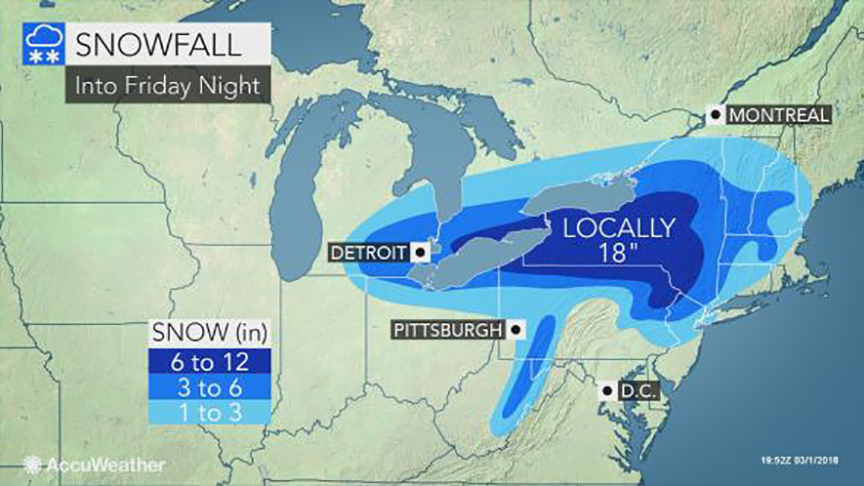
The next storm is on the horizon, expected to produce heavy snow for many regions of Quebec. (AccuWeather.com)
Looking ahead to this week, another major system is forecast to develop on Thursday along the east coast. This system will not be as strong as last weeks storm, but still have an impact on our weather. Depending on the exact track and proximity to the coast, some locations in southern Quebec may have a significant snowfall. At this time, the heaviest snow, in excess of 20cm (8 inches), will likely fall across the Townships, areas near the US border and in New England. Winter storm watches are already in effect across upstate New York and most of New England.

Snow will arrive in Montreal early Thursday and persist into Friday. I am thinking a general 10cm is likely for Montreal, but that is subject to change. Look for updates throughout the week as the picture becomes clearer regarding this storm.

Thursday, March 01, 2018

Powerful coastal storm to graze southern Quebec

So close and yet so far. Southern Quebec will remain on the northern edge of another coastal storm. Only flurries and strong winds are forecast Friday for Montreal. (AccuWeather.com)
Strengthening low pressure will slide across the state of New York overnight, delivering heavy snow and strong winds from Michigan into southwest Ontario and New York. The storm will move off the New Jersey coast on Friday and rapidly deepen into a major Nor'Easter.

Tonight, the bulk of the heavy wet snow will fall from Windsor, Ontario eastward into the Niagara region as well as the Adirondacks. A general 10-30cm of snow is expected. Strong winds will gust over 50km/h, producing poor visibility. On Friday, the axis of heaviest precipitation will occur across New England and the northeast. Southern Quebec will remain on the extreme northern edge of the storm, with flurries and strong northeast winds developing Friday. Wind gusts may exceed 70km/h in the St. Lawrence Valley. The clouds and gusty winds will hold temperatures either side of 0C (32F) through Friday. Any snow accumulations will be in the order of 2cm, and confined to the regions south of Montreal.

Damaging Storm
Along the southern and eastern New England coastlines, residents are preparing for a major storm. Winds are expected to gust to hurricane force, 75mph or higher. Coastal flooding will be a major concern as the storm slowly moves into the Atlantic. Three successive high tides are expected during the duration of the storm, each pushing a tremendous amount of water onto the coast. Evacuations may be needed in several locations. Severe coastal impacts are expected. In addition to the wind and waves, 50 to 100mm (2-4 inches) of rain is possible. Widespread power outages are likely. The hardest hit area at this time is expected to be along the Massachusetts and Rhode Island coast.