 |
| A spectacular end to a beautiful Saturday on L'Ile Perrot. |
We will see a similar day today with a little less shower activity, but still the risk of some decent thunderstorms this afternoon. The day starts off with a little sunshine but the air will rapidly become unstable with the showers developing by noon. Skies will clear tonight and we should see a return to sunshine for the middle portion of the week, Temperatures will be below normal today at 22C (72F) but warm to 26C (79F) for Tuesday. It was a cold weekend in places west of this storm system like the the upper Midwest and northwest Ontario, well below normal for July. There was even a frost advisory overnight for northern Minnesota.
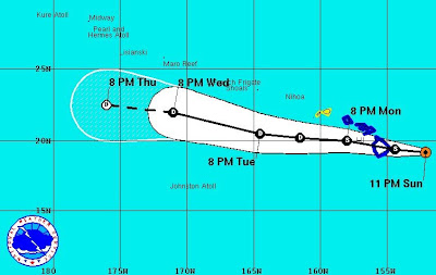
Flossie
A rare event is occurring today with the arrival of Tropical Storm Flossie on the Hawaiian Islands. Flossie this morning is about 200 miles east of Hilo moving west at 17mph. The center is forecast to cross the Big Island this morning and move across the rest of the region over the next 24 hours. Flossie is expected to produce torrential rains, 50-60 mph winds and very high seas over 20 feet with coastal flooding. Despite the islands being very vulnerable in the middle of the Pacific, Flossie is the first system to affect the island this century, the last coming in September 1992 when Hurricane Iniki pounded the islands.

No comments:
Post a Comment