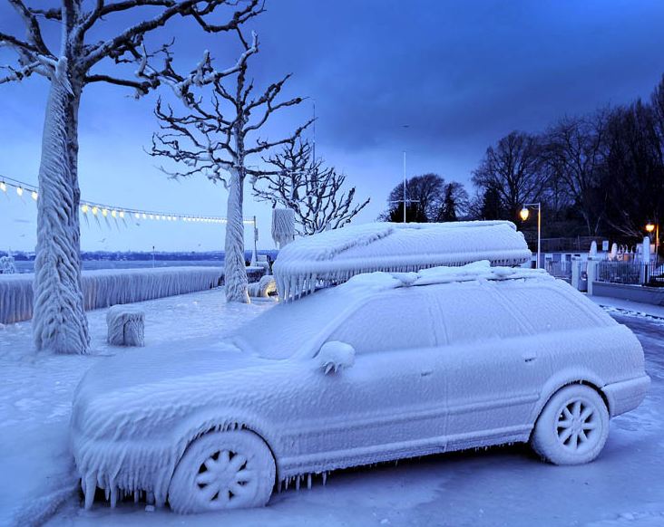
Ice coats cars along Lake Geneva as Europe shivers while Canada remains relatively warm. (National Post)
A strong cold front swept across the region overnight with very little in the way of precipitation, but a wind shift and much colder temperatures this morning. Several records were established yesterday across New England, Ontario and Quebec including 5.1C in Ottawa beating the old record of 3C from 1991. It was 4C in Montreal, 8C in Toronto and 9C in Burlington, Vermont. Most areas south and west of the city have very little snow left to speak of, here on L'Ile Perrot we have an icy 10cm (4 inches) or so still lying around. No major storms are in sight this week and into the weekend. The only weather to speak of will be another arctic front Friday night that could produce a period of flurries and perhaps a squall or two with its passage. Otherwise high pressure will dominate the week with temperatures mild for February. Highs have been reached today with temperatures falling by afternoon and evening down to -14C in Montreal. The balance of the week will see highs near -3C and lows around -16C. The weekend looks a little colder but again no major storms on the horizon.
The cold this February appears to be trapped across central and eastern Europe where some of the coldest and snowiest weather in over 25 years is affecting regions from Scandinavia east into Serbia and Romania. Governments have declared states of emergency with the death toll now exceeding 300 from the extreme cold and storms. Record lows have been established in many areas including as cold as -40C in the Czech Republic. The cold has frozen waterways across Europe including ice on the canals in Venice. Schools were closed in Rome as heavy snow fell.
No comments:
Post a Comment