 A hurricane watch is in effect for the entire North Carolina coast including the Outer Banks. Irene remains a large and powerful category 3 storm this morning with every indication that she will gain strength over the warm waters east of Florida today. The storm counties to tear into the Bahamas with heavy rain and strong winds. There have been reports of flooding, damage and power failures. Once the storm clears that region it will take aim at the Carolina coast and points north.
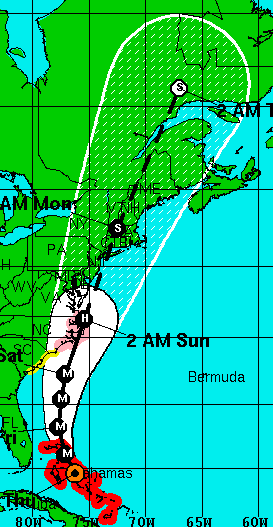
There is increasing concern along the middle Atlantic and northeast into New England and eastern Canada this morning. The region had heavy rain last week and the potential for serious flooding exists. At this time hurricane conditions will spread across the Outer Banks Saturday, evacuations are underway today. On Sunday the storm will move northeast along the coast and slam into Long Island. The forecast track at this time, subject to change, ha
 s Irene moving into New Hampshire and then southern Quebec as a tropical storm. East of the track heavy surge and wave action will affect the coast while along and west of the track heavy rain and strong north and northeast winds are expected. With this track, Montreal would remain on the western edge of the storm with rain and strong winds by Sunday. I will have much more on Irene as the day moves along with the next complete update this evening. All the links on this page are active with information.
Above: The NHC forecast track for Irene.
At right: Two locations I know so well on the Outer Banks. I have waited at that ferry terminal on Hatteras Island 100 times if not more.
No comments:
Post a Comment